Observation des dégâts de la grêle sur les cultures au moyen d'acquisitions satellitaires
Observation of hail damages on vineyards using satellite acquisitions
The studied hail event has occurred on May 12th, 2004, in the neighbourhood of Lézigan-Corbières, Aude, France.
The SPOT images acquired for this study have been purchased to SPOTIMAGE. They are:
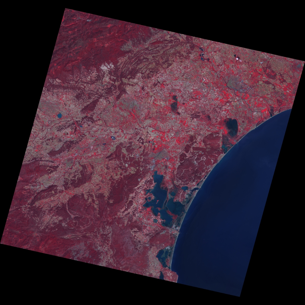
A quicklook of both images is displayed below. Click on images for a larger view.
 |
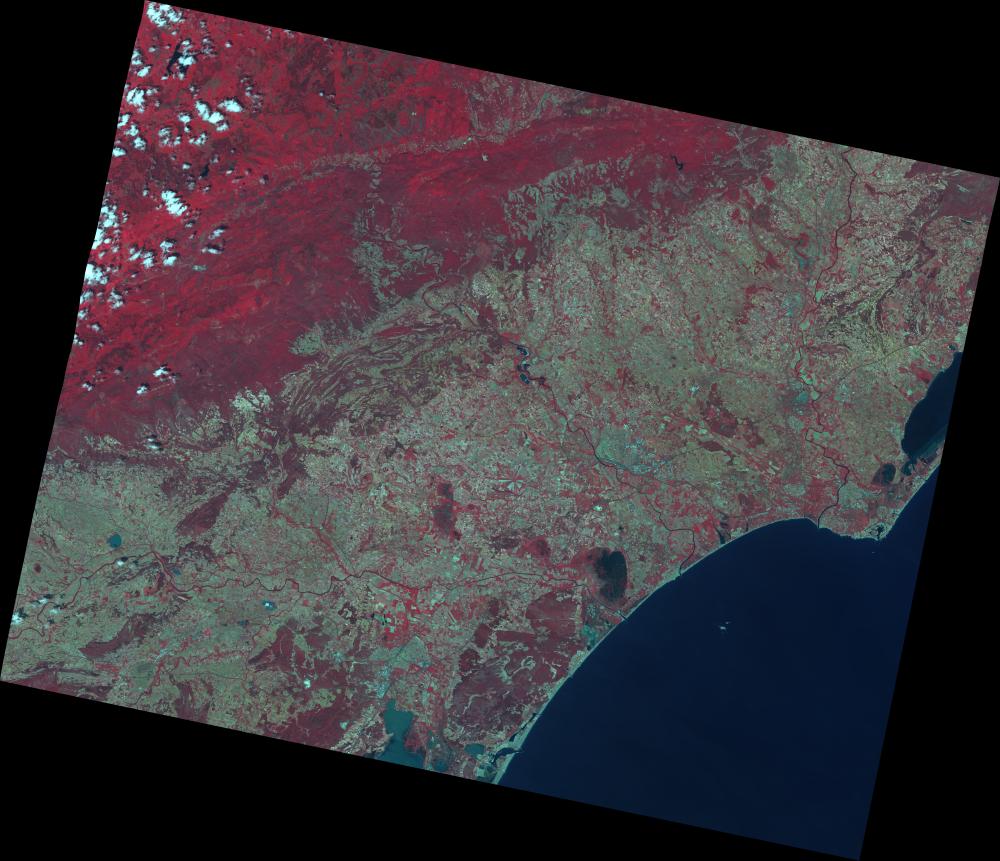 |
Image T0 |
Image T1 |
Ground truth is constituted of hail damage assessments manually performed
by insurance experts: the loss in final production, defined in percentage
with respect to the expected final production. Hail damage assessments
are available for a set of parcels,
observable on the images. This set is subdivided into two subsets: E1,
constituted of 32
parcels of area greater than 0.6 hectares, E2, constituted of
19 smaller parcels. The set E1 is constituted of parcels corresponding
to enough pixels on satellite images for computing statistics.
For each parcel, the following information is available: area, potential production and yield, estimated loss of production, identification of farmer and of expert. Each parcel is further identified in the cadaster and is located on the satellite acquisitions.
An additional set E0, constituted of 55 parcels, has been selected outside
the hail area. The latter set is considered as a reference, from which
statistics of non damaged parcels are computed.
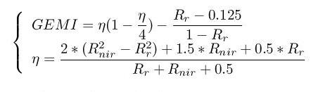
Vegetation indices have been computed from the red and near infrared SPOT reflectances. After comparative studies, the GEMI (Global Environment Monitoring Index) has been selected. GEMI is designed with a non linear combination of reflectances, in view of minimizing the relative influence of atmospheric effects such as thin clouds and haze.
Let i be a parcel with Ni pixels. A criterion is defined to characterize, at the parcel level, the global evolution of GEMI between the two acquisition dates. This criterion is defined as the mean over parcel i of the relative variation of GEMI between the two dates.
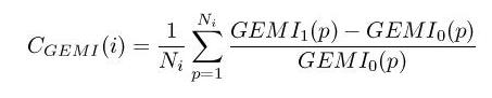
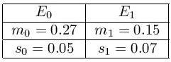
The criterion is computed on the set E0 of 55 references parcels. Its mean m0 and standard deviation s0 inform on the variability of the criterion for non damaged parcels. The same computation is performed on the set E1 of 32 damaged parcels, yielding mean m1 and standard deviation s1. Their value are given in the table below. A Student statistical test confirms that m0 and m1 differ and hence the criterion Cgemi has a a value significantly different on damaged and non damaged parcels.
The graph below depicts:
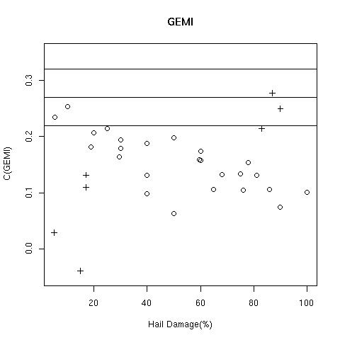
Most damaged parcels have a value Cgemi significantly lower than the three horizontal lines, indicating that the GEMI vegetation index has less increased on damaged parcels than on non damaged ones, thus confirming that hail has altered vegetation growth.
The graph furthermore exhibits a clear negative linear correlation between Cgemi and hail damage assessments, with the exception of seven parcels out of tendancy, marked with crosses. An effect of vine is suspected for these parcels.
Linear regression has been used to assess hail damage from satellite images. It has been computed on parcels marked with dots (defining set E) and is displayed in the graph below.

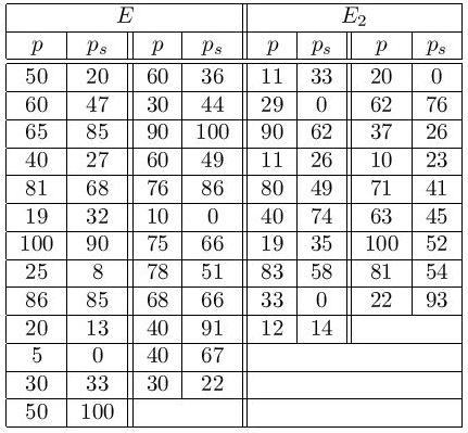
Hail damage assessments ps are computed from Cgemi using the linear regression for each parcel, and compared to the corresponding value p, estimated by experts. The comparison is given in the table below for parcels of sets E (large parcels used for regression) and E2 (small parcels). The overall error (mean value of |p-ps|) is 18%, which is reasonable and allows to conclude on the feasibility of assessing hail damage to vineyards by satellite.